Showing posts with label navigation. Show all posts

06/03/2010

Marin . cc, Media Art Research Interdisciplinary Group


Thanks to Felipe Fonseca, Metareciclagem for the link.

Media Art Research Interdisciplinary Group
M.A.R.I.N. is a networked residency and research initiative, integrating artistic and scientific research on ecology of the marine and cultural ecosystems.

For the first three years M.A.R.I.N.’s operational focus is a mobile residency program set on a catamaran sail boat, redesigned and equipped to be a sustainable environment for transdisciplinary research in arts, sciences and technology. Emerging from long experience of collaboration within media art, M.A.R.I.N. develops a new, integrative arts/science/technology practice model.

Areas of research :
MARINE ECOLOGY (cyanobacteria, alien species)
LITTORAL NARRATIVES AND MAPPING
OPEN TECHNOLOGY SYSTEMS
MARINE ECOLOGY 2 (spillage, overnutrition, heavy metals)
WEARABLE COMPUTING AND ECOLOGICAL SENSING FOR THE SEAS

Map interface_01

16/12/2009

Avoiding death at sea

That's quite an old article, but it still valid today for most unfortunately.

Friday, 16 August, 2002, 00:21 GMT 01:21 UK
Fishing 'most dangerous job'
Fishing trawlers
Of every 100,000 fishermen, 103 will die at work.


Fishermen and merchant seafarers have by far the most dangerous jobs in Britain, according to experts. A study by researchers at Oxford University has found people working on the sea are up to 50 times more likely to die while working, compared those in other jobs.
Their jobs are much more hazardous than those in the construction or manufacturing industries and also a lot less safe than working for the police, army or fire brigade.

Most dangerous jobs
1. Fishermen
2. Merchant seafarers
3. Aircraft flight deck officers
4. Railway lengthmen
5. Scaffolders
6. Roofers and glaziers
7. Forestry workers
8. Quarry and other mine workers
9. Dockers and stevedores
10. Lorry drivers

The researchers said their findings highlighted the need for urgent action to reduce the risks of working on the sea.
Dr Stephen Roberts analysed official death statistics from a range of different professions between 1976 and 1995.
He found that 103 in every 100,000 fishermen died while working. This is 50 times higher than other workers.
The vast majority of these deaths were from drowning. However, there were also a sizeable proportion of lives lost as a result of injury and asphyxiation.
Figures for merchant seafarers showed 52 per 100,000 died while working.
A large number of these deaths were attributed to trawlers foundering in adverse weather.
However, a significant proportion was linked to collisions and groundings.

Safe jobs
The figures compare to rates of just 2 per 100,000 for the rest of Britain's working population.
The safest jobs, according to the study, are those in the service sector which has death rates of 0.7 per 100,000 workers.
Writing in The Lancet Dr Roberts said his findings backed up previous studies.
He said: "Trawler fishing and merchant seafaring are still the two most dangerous occupations in Britain."
Dr Roberts said the unique challenges of working on the sea were to blame for the high death rates.
"Trawler fishermen have to contend with unique occupational and weather-related hazards. These, together with economic pressures, often make this industry unreceptive to the introduction of safety measures."
But he added: "Prevention efforts should be directed, most importantly, towards reduction of hazardous working practices in trawler fishing.
"In particular, they should be aimed at the unnecessary operation of small trawlers and net manoeuvres in hazardous weather and sea conditions."

Safety campaigns
The Maritime and Coastguard Agency (MCA) said it was working to reduce deaths on the seas.
A spokeswoman told BBC News Online: "The MCA is well aware that fishing and seafaring are by far the most dangerous jobs in Britain.
"We do targeted campaigns year on year looking at different aspects of safety to try and make fishermen aware of the risks and to enable them to help themselves."

 
Same for American statistics :


This is not to mention the thousands of people diying every year candidate for illegal migration...


As designer and architects, can you bring design ideas to adress theses issues?
We have good boats (sailing), good petrol platforms (standing), but there seem to be a category in between : drifting architecture, that does not have appropriate architecture yet.
If there is one architecture we want to pursue, in the making of the International_Ocean_Station, this is this drifting architecture we are aiming at. We dont really have any reference yet ... we must invent this new family of crafts, between boats and oil rig.

Does it have to be large solid metalic structures? I dont think so. It is probably highly flexible, reconfigurable organic low-cost structures we must think of.

What if fishermen had permanent drifting sustainable fisheries and fish farms?
What if coast guards had permanent observation points, or low efficient  cost life-saving infrastructures?
What if oceanographers, meteorologists had a good platform for ocean research and expeditions?
What if we were able to collect marine debris?
Help us.


14/12/2009

Open Call for projects - Curated Expedition to the Baltic Sea


The Baltic Sea, Kaliningrad region of Russia ©Petr Antonov

The Curated Expedition to the Baltic Sea invites artists to contemplate the natural phenomena and their own relationship with the changing sea. Researchers and other cultural agents are encouraged to join the expeditions, straddling the borderline between art and science.

Artists who live in Finland or Estonia, irrespective of their nationality, can take part in this open call. Also Finnish and Estonian artists living abroad may participate.

The project is intended to spur new works of art and inspire the public to take part in different creative processes. Artists decide, whether the general state of the sea is the phenomenon studied, or one of it´s numerous and singular phenomena and ecosystems will be under their exploration.

One of the key aspects of the marine expeditions is to travel slow, using methods of transport that only moderately burden the environment. A canoe, a hot air balloon, a jolly-boat, a marine research vessel or a rowboat are just some possible means of seafaring, used by artistic sea explorers.

Project proposals will be accepted until 21 December 2009. The project will be part of Turku’s programme for the European Capital of Culture year in 2011. Capsula and Bioart Society Finland are responsible for the project.

More information and the instructions for the application:

More information about the 1st Curated Expedition to the Total Solar Eclipse:http://capsulaexpeditions.com

>> So, shall we do it?
>> Are we going to be ready on time?


An interesting article about fisheries in the Baltic sea.


Great article about the Baltic sea and its actual condition (below).
http://www.helcom.fi/environment2/nature/en_GB/nature/


The Baltic Sea is a small sea on a global scale, but as one of the world's largest bodies of brackish water it is ecologically unique. Due to its special geographical, climatological, and oceanographic characteristics, the Baltic Sea is highly sensitive to the environmental impacts of human activities in its sea area or in its catchment area, which is home to over 85 million people.


What makes the Baltic so sensitive?


An almost enclosed sea

The Baltic Sea is only connected to the world’s oceans by the narrow and shallow waters of the Sound and the Belt Sea. This limits the exchange of water with the North Sea, and means that the same water remains in the Baltic for up to 30 years – along with all the organic and inorganic matter it contains.
The Baltic Sea consists of a series of sub-basins, which are mostly separated by shallow sills. These basins each have their own water exchange characteristics.

Runoff enters the shallow Baltic Sea from a large catchment area

At an average depth of just 53 metres, the Baltic Sea is much shallower than most of the world’s seas. It contains 21,547 km³ of water and every year rivers bring about 2% of this volume of water into the sea as runoff. The Baltic Sea’s catchment area is almost four times larger than the sea itself.

Brackish water

The brackish water of the Baltic Sea is a mixture of sea water from the North Sea and fresh water from rivers and rainfall. Thesalinity of its surface waters varies from around 20 psu (≈parts per thousand) in the Kattegat to 1–2 psu in the northernmost Bothnian Bay and the easternmost Gulf of Finland, compared to 35 psu in the open oceans.

A stratified sea

Salinity levels also vary with depth, increasing from the surface down to the seafloor. Saltier water flowing in through the Sound and the Belt Sea does not mix easily with the less dense water already in the Baltic, and tends to sink down into deeper basins. At the same time, the less saline surface water flows out of the Baltic. The boundary between these two water masses, known as thehalocline, consists of a layer of water where salinity levels change rapidly. In the Baltic Proper and Gulf of Finland, for instance, the halocline lies at a depth of around 60–80 m. Like a lid, the halocline limits the vertical mixing of water. This means that the oxygen content of the deep basins may decline due to biological and chemical oxygen consumption. The Baltic Proper is replenished by oxygen-rich saltwater flowing in from the North Sea along the sea floor.
The Gulf of Bothnia, separated by a shallow sill from the Baltic proper, has low bottom water salinity and, hence, a very weak or absent halocline. In summer a thermocline – a distinct layer of water where the temperature changes rapidly – divides surface waters into two layers: a wind-mixed surface layer down to a depth of 10–25 m, and a deeper, denser and colder layer extending down to the sea-bed or the halocline. Such temperature stratification ends as surface waters cool in the autumn.

Limited biodiversity

Compared to other aquatic ecosystems, only relatively few animal and plant species live in the brackish ecosystems of the Baltic Sea – although this limited biodiversity does include a unique mix of marine and freshwater species adapted to the brackish conditions, as well as a few true brackishwater species. Where salinity levels are low, in the Baltic’s northern and eastern waters, fewer marine species can thrive, and marine habitats are dominated by freshwater species, especially in estuaries and coastal waters.


Figure 1. Specific features and processes which make the Baltic Sea sensitive (green - natural characteristics, white - human impacts, yellow - harmful effects)


12/12/2009

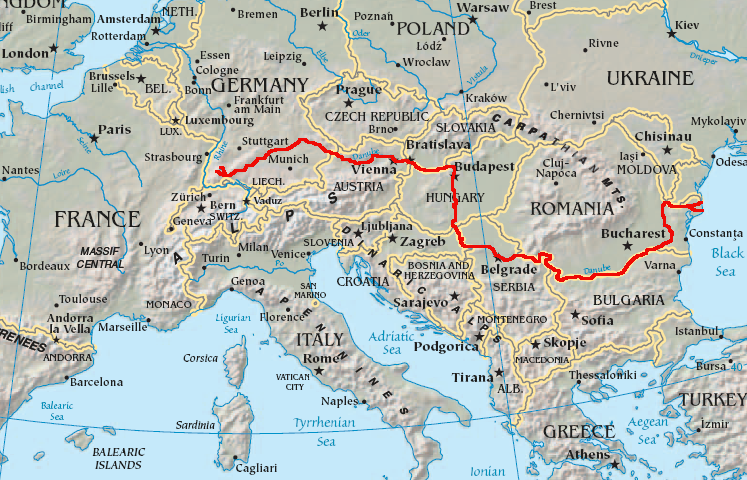
Navigating the River Danube

(article to be completed)

I have been doing some research into the sailing conditions etc on the Danube. I have had difficulty finding definite legal restrictions for things like vessel size and water speed, so if anyone does have/find any such figures please let us know!


Water speed-

The Danube is between 100-200 m and 2 km wide in its lower section. It flows along peaceably. Not more than 5 km an hour on average. The waters from the Alps, the Carpathians and the Balkan mountains feed it as it meanders between towns, forests, vineyards and fields of cereal crops. Thanks to a flow of 6,850 m3 per second, it can be navigated by the largest of vessels after Ratisbonne. Fifty cruise ships and convoys more than 350 m long transport dozens of tonnes of merchandise per year, pass each other in this water course which also provides colossal amounts of hydroelectric energy for Austria and Hungary and especially for Serbia and Romania, which share the power station at the "Iron Gate". This channel, which is 80 m wide and 3 m deep over 2,200 m, has been hollowed out of the rocks referred to as the Iron Gate (the name given to the Djerdap gorge which separates the Balkans from the Transylvanian Alps) to eradicate forever the reefs which, for centuries, had hindered international navigation on the Lower Danube. This gorge has made it possible to link East and West.

http://cruise.croisieurope.com/cruise/european-rivers/danube/river-story.html

"There are unfortunately many channels in the danube. From start of the bulk shipping street in Kehlheim, the locks have again larger distances. Strong current changes with back-ups before the obstruction walls. Behind Vienna only 2 channeling, from there it is possible to travel freely and fluently to the iron gate at the Romanian boundary. Before Budapest and behind Belgrade, one must reckon with violent Fallwinden. Covered boats are then unconditionally necessary. "

http://www.werow.com/mod.php?mod=guide&op=show&postfix=donau&lang=ENG

Hungary 6-7 Km/h
http://kation.elte.hu/e/acidrain.htm

Climate, Landscape, Pollution etc

a great website from the International Commission for the Protection of the Danube River (ICPDR) giving information on the Danube in various sections, including info on climate, pollution, landscape and water flow
-http://www.icpdr.org/icpdr-pages/home.htm

http://www.blacksea-commission.org/main.htm

http://www.grid.unep.ch/activities/global_change/danube.php

Locks, dams and bridges

The height of locks along the Danube--

http://www.doris.bmvit.gv.at/en/services/locks/locks_anlong_the_danube/

Sectioning

* Upper Section: From spring to Devín Gate. Danube remains a characteristic mountain river until Passau, with average bottom gradient 0.0012%, from Passau to Devín Gate the gradient lessens to 0.0006%.
* Middle Section: From Devín Gate to Iron Gate. The riverbed widens and the average bottom gradient becomes only 0.00006%.
* Lower Section: From Iron Gate to Sulina, with average gradient as little as 0.00003%.

(http://www.newworldencyclopedia.org/entry/Danube_River)

The Path of the Danube-descriptive

As I said, I have had difficulty in finding specific widths and depths so far but I'm sure they are out there so feel free to add.

General Description of the Danube's path through Europe
http://www.cruisingholidays.co.uk/river/blacksea/index.htm

With an overall length of over 1800 miles, the River Danube flows from
its source in the Black Forest of Germany through eight countries to
the Black Sea - it is the only major European river to flow from west
to east.

From Nuremberg the Main-Danube Canal leads to the River Danube. The
river flows through Austria to its capital Vienna and on to Budapest
in Hungary.

From Budapest the Danube flows south through the Hungarian plains, and
then turns east through Serbia.

The river passes through Belgrade with its ancient streets and
Kalmegdan fortress above the confluence of the Sava and Danube rivers.
The scenery becomes dramatic and the life more rural.

After passing through the spectacular ‘Iron Gate’, a dramatic Danube
gorge between the Carpathian and Balkan mountains, the river forms a
natural border between Bulgaria and Romania on its way to the Black
Sea.

http://www.werow.com/mod.php?mod=guide&op=show&postfix=donau&lang=ENG

a website detailing water conditions along the river-key is in German

http://www.romaniatourism.com/danube.html. - a useful guide to boating on the Danube in Romania-includes a description of a river boat trip terminating at the black sea

http://www.danube-cooperation.com/library/2004montalenti.htm

Another description of a trip fown the danube to the black sea. Some useful book titles mentioned here-

The Danube - A River Guide by Rod Heikell - Imray Laurie Norie & Wilson
The Danube - a river's lure, Yachting guide 2003 - Danube Commission
Pleasure Navigation on the River Danube by R.W. Cooper - Conference Nov 13-14 2003 E' Oriente by Paolo Rumiz - Feltrinelli
Danubio by Claudio Magris - Garzanti
Back Door to Byzantium by Bill, Laurel Cooper - Sheridan House

Boating Info

http://www.cabri-volga.org/DOC/EG4/ManualDanubeNavigation.pdf.
sailing manual for vessels on the danube

http://www.dpc-belgrade.rs/project_mutand.htm#THE%20DANUBE%20WATERWAY%20AS%20A%20TRANSPORT%20RESOURCE
-project mutland- MUTAND - MUltimodal TraANsport on the Danube River

http://en.wikipedia.org/wiki/Trans-European_transport_networks

http://findarticles.com/p/articles/mi_m0FCP/is_1_23/ai_76549192/.

I am currently looking into

a) Specific measurements necessary (max and min) for vessels travelling down the Danube

b) Boating forums

c) Rules regarding Matriculation and Boat Captains

OK so that is where I am at the moment, as I have said twice now and will say again to reaffirm PLEASE FEEL FREE TO EDIT

Before I finish for now I will mention two more useful websites:

http://www.donauschifffahrt.info/en/

-a website detailing navigation along the Danube (though I have not yet succeeded in finding actual data)

http://www.osce.org/documents/eea/2008/01/29416_en.pdf

-the economic importance of the Danube Region

Et voila, for now
Samantha Penn


http://www.via-donau.org/en/
These are the technical drawing for the pulleys and the roller mechanism made by Gerard Rallo.

This is going to be construct in Berlin in the next week in Atelier KW (where the Biomass Production Module is build too)

roller-mechanism3

Nomadic life, agriculture in movement

http://www.varmatin.com/edito/photo/510/20080221/photo-119773-3293959222c7cb11ff58a1384fc73208.jpg

We are going to move. We need to feed ourselves while not damaging the ecosystem we are passing by. We would like to put together a nomadic ecosystem as we move, and adapt it progressivly as we move.

- What are the cultures we are able to make ? Which species have the potential to adapt?
- How easy is it to create a trophic level.

The Danube is our playground :

File:Danubemap.png

What is the most interesting perhaps, is  the transition from a freshwater to a salty environment :

File:WOA05 sea-surf SAL AYool.png

and this is life on the water : the biomass on the sea :

http://nordpil.com/static/images/ocean_productivity_full.png

OS_Polar - concept development

<Rupert>t sent me this the other day.
-------

Hi Guys


I am attaching some ideas (I hope you can read them- sorry for the low resolution, but we are having serious network problems at the moment- please put up on the Blog if anybodys got the time.)


-) The Leg:
I did some rough calculations on the buoyancy with the dimensions given, and thus placed the foot when it is in the retracted position above the water line. (i.e. allowing it to climb onto sea-ice during the ice formation.) The piston would be above the level of the floor, and could double up as structural points. Where the pistons should be placed in plan is to be decided. I would recommend one on the inner circumference, and two on the outer - depending on how you decide to internal layouts.
I am a bit concerned about the lateral loading on the piston legs in winds and when mobile. It would need to be determined at what weather conditions the base would drop to the ground to protect itself.( Although a gust may hit unexpectedly! ) Perhaps the piston could get support for other rods that contract with the piston.

-) The Foot.
The foot is designed almost like a ducks foot. Side-on - when outside its housing, but not on the ground - it is shaped like a banana. when on the floor it is curved. There are no "mechanical" parts but is hinged on the leg and can swivel in the direction of the long axis (heel-toe) about the short axis. The webbing is a flexible heavy duty material which is stitched to hold the "bones" of the foot in place. When the foot is raised it will change shape and ripple, the material allowing snow or other debris to fall off. Ultimately when retracted into its housing it will flatten to fit in the housing grove. (see section views)

-) The Foot extension
The leg could continue through the foot to allow for an attachment point - perhaps simply a threaded end. To this a rubber sleeve could normally be attached, for standing on solid ground & to protect the thread. Alternatively when mobile it would be the attachment point for skis or tracks.


______

-) Dimensions

I have just included some general dimensions that I was working with.
-Inner Radius: 1800mm
-Insulation layer: 200
-Outer Radius: 2000
-Floor Level at 60º off vertical (120º chord)

-Ring Outer Radius: 6875+200
-Ring inner Radius: 3275-200
(where 200 is the insulation layer)


______
-) Lighting

The use of natural lighting by means of reflection. Idea being to have light and shadows directed from above. Due to shadows created from other segments of the base, the layout attempts to capture direct sunlight outside of the shadow by having it at the highest point. This means that when the sun is only a few degrees above the horizon all cells will receive direct sunlight. Due to the curvature in each cell no matter what position the cell is in it will always receive direct sunlight.
A mirrored surface (which is curved in one direction) redirects the light. (The straight edge is 45º to the horizon.)

[floor - celling 2100mm]

¿a system of blinds / curtains required - how ?

- Eye level windows optional where required.


______________
Interlocking cells.

The procedure for merging cells is the following:
- The pistons with there latching mechanism are extended.
- The pistons are manipulated inside the cell, in its "ball and socket" joint.
- The two piston are locked onto each other.
- Each piston is pneumatically pumped and retracts its shaft.
- Dimples help the alignment of the cells
- Once in place the cells are magnetically locked / bolted together

(The "Ball" of the joint would ~200mm in diameter -wall thickness. The dimple size needs to be of a comparable size for ease of use.)
=The central piston above the door could have a longer reach to for "first contact", before secondary less dynamic locking points make contact.
= Possibly only one piston is required, tertiary locking point could just be bolted/magnetically coupled


All my ideas for now....
Rupert

P.S. I will write up the turbine document as soon as I can.
-------------
Rupert>


Junkraft

http://junkraft.blogspot.com/


A very impressive and quite similar project to Open_Sailing, the Junkraft, by Dr Marcus Eriksen, Joel Paschal and Anna Cummins. They sailed from California to Hawaii on a raft made with plastic bottle to raise awareness about the topic of the plastic sea, as the plastiki is doing now. How is it actually made? Do bottles resist that much long exposure to salty sea environment? Can we rely on these bottles?

Rotterdam - Linz navigation on canals

If we ever reach Rotterdam with the Open_Sailing01, what shall we do?
Let's go to Linz. Why? Why not. You will know soon enough... Heheheheh!

http://farm2.static.flickr.com/1110/652413018_8935b047c2.jpg?v=0

But it seems possible to do this looong distance by boat : From North sea to Black Sea !

north-sea-black-sea

By the Rhine, the Main and Danube. It is a sort of aquatic highway as a matter of fact.

barge-operator

Many barge operators work on this itinerary. Probably cheaper than truck (probably a lot slower too), and maybe we dont have to cut our boat in small pieces and make it fragile ...

Kite-runner / Rudder-less Sailing!

<rupert>

Just some design concepts for getting up wind... with out the need of a rudder- but a deep keel!
Depending on the size kite / wind strength the mounting & rings might have to take quite load.

There is an alternative to useing a ring of less than 360º but that would require the "tack" to turn the whole vessel around! The idea is a major addition/complication as it would need a clear run all the way around the vessel and nothing can run over the top of it. - Although the double ring would also work as a safety banister if mounted waist high- "killing 2 birds with one stone".

opentack100011
the Tacking process.

[caption id="attachment_1346" align="alignnone" width="450" caption="Tacking process. (wind from the North, vessel heading from south to north / bottom to top)"]Tacking process. (wind from the North, vessel heading from south to north / bottom to top)[/caption]

A concept for the runner...

[caption id="attachment_1350" align="alignnone" width="450" caption="Kite runner"]Kite runner[/caption]

Material wise- the rings could be made in the same manner / same material as windsurfing masts, but you have the added problem of the point loading of the wheels - instead of runner wheels on the inner side a "sled" could be made to distribute the force on the rings.
rupert>

23/11/2009

Open_Sailing prototype 2 Paris

Learning from the first experiment, we wanted to optimize the design of the Open_Sailing_01, this is prototype Paris nº 2.


Download quicktime (31mb) | Vimeo | Youtube | Dailymotion | Sevenload

So according to the prototype Paris nº 1 and its defects, we have changed :
- enhance capability of self-righting (more floatation on top on every side)
- reinforce overall structure with metal mesh rebar
- Addition of the flexible ballast (inspired by Givens invention)
- make the 3 hulls deeper and slightly curved to dive in the waves more smoothly.
- have 2 anchoring points for 2 kites attached to the main frame front
- have 2 lateral openings on each side for fishing and rowing (alternative emergency propulsion)
- main openings to have an doorstep higher to avoid too much water entering in at all times.

shipais.com, amazing feed

http://www.shipais.com/currentmap.php?map=thamesrhine

shipais1

shipais2

Really cool feed of major ship positions. Below, from their FAQ :

http://www.shipais.com/what.php (very interesting page by the way, telling us who need to publisize its position constantly by categories).
As part of the global maritime safety system, ships over 300 tons are now required to broadcast their positions using AIS.
A ship transmits "dynamic" information at intervals of between 2 and 12 seconds depending on the vessel's speed or 3 minutes if at anchor.

Thanks to Ollie Palmer for the link.

Currents North Sea

from a very nice Belgium website;

http://www.mumm.ac.be/NL/Models/Operational/Currents/animation.php#tb

The North Sea has very strong surface currents, water trying to run through a very small opening in the channel when tides come and go. These currents are for sure something to keep in mind.

Here some images from an animation at the site above. Red is 1>meter per second, dark blue is <0,1 meter per second. Even when you drift with the strongest currents and they go exactly the way you want them to go, it is still going to take quite a while to cover the 350 km. Especially when those currents flow the other way again 6 hours later.

Do we have a +/- 200 meter anchor line?

currents

40 knots to know, more later

knots2

By Martin Gautron

Drifting across the North Sea

As we need backup plan, what if we simply build in London, and drift it down the Thames, into the north sea, toward the Netherlands? London - Rotterdam, not bad. It is also shorter, and there is more people around to ensure safety.

london-rotterdam

London to Rotterdam = 350 km.

350px-north_sea_currents

These are the main currents.

Loading Storm Graphics Loops

Wave height

Superforecast UK England Southeast

Superforecast Germany North Sea

Winds in the UK (southwest north sea), Netherlands

Well, it actually sounds simpler and safer than Morocco to start with. Also, it is quite "simple" to bring our object back to London to exhibit it for the RCA SHOW. We could let people visit our machine and attract more investors for future plans ! Also being in Rotterdam could be good to meet deutch people, that's quite a massive construction harbour in there.

Navigation

We are working to make sure our semi-autonomous navigation system will be better than those used on expensive nuclear submarines (and a lot cheaper!)

Previous expeditions in the name of research

In the interests of research, whilst at university, some friends and I ran an annual cruise down the River Taff in cheap inflatable boats. It just so happened to be a brilliant day out, complete with beer, relaxing, and – unusually for Wales – sunburn. All in, it cost around £5 each for a day on the river, including a couple of beers. If you are a student, you live in town with a slow river, and it's sunny, I'd recommend organising something similar.

dsc00376dsc00375dsc003771dsc003783dsc00373

We naturally found that we grouped the vessels whilst just sailing along. We sailed mostly on drift (like Open Sailing) with occasional separation for paddling. We rode down wiers, over stones and down the rapids, over broken bottles, into abandoned trolleys, and lost just one boat per year. The grouped structure worked best for handling the weirs, both in terms of not capsizing and adding a bit of a challenge.

It's remarkable how well a series of boats costing less than £10 survive a day of intensive sailing, particularly given that they were laden with two or three fully-grown adults, yet supposedly designed for kids.

All in the name of research...

Ollie Palmer

Tribal Search Engine

Hiromi Ozaki and  Cesar Harada invented the "Tribal Search Engine":

We have the technology to make this world a better place, but as of yet we haven’t quite managed it - because we don't seem to know each other very well, and we don't collaborate efficiently enough. The Tribal Engine is a social search engine which can bring people with similar interests together to solve problems together.

A traditional search engine simply offers you a list of results from a search query. During a search, you would normally think alone, and solve problems alone. Using the Tribal Search Engine, you enter your likes, dislikes, fears and interests related to a physical space. The Tribal Search Engine suggests you a location, you go there in the physical space, and you meet people with the same questions, interests or fears. Together than, you resolve the "problem".

For example, you could set the parameters to indicate that you like good food and dislike loud music venues in order to decide where to go on a Friday night. You can then view other people who have gathered near your results in real time – they are likely to be the people who share similar interests. From there you can meet in physical space or online to collectively decide where to go, or even solve problems related to your interests and fears. By talking to and sharing knowledge with people doing the same search together you can dramatically speed up your problem solving!

19_0001usersweb
Users in different locations entering constraints to find optimal locations

19_animmm
Tribal Engine suggesting areas - you can adjust how much you like or dislike certain things with the sliders.

19_003togetherweb
Users with similar constraints meeting in physical space

19_global-threat-anim
Tribal Search Engine works on every scale, from a urban block to the world map, here it is suggesting safe areas to avoid global threats.

From the datas 2012hopes threats collected, Tribal Search Engine determined the location and the dynamic shape of the fluid structure of the Open Sailing. That's our concept.
19_005diagramdi
Timeline Comparison of Google and Tribal Engine. Google lacks physical existence, Tribal Search engine brings real people in real space to solve the real problems of this world.

14/11/2009

Steam engine


We love the pop pop engine system (membrane)

boat2


indianboat02
dick02
boiler01
CIMG0949-261x179

Buy Pop pop boiler, one large for 4$


Many

AMAZING JET BOAT DIY : with recycle materials and easy weldings.


test board 02


We can also buy this amazing engine :

Pop-Pop Engine
Pop-Pop Engine Ref: USE22
One of the most charming sources of power for model boats has always been the POP-POP, very popular in the 1930s it's reapperance is long overdue. One engine will push a hull about 30cm long, and we have run a metre long boat with four! It runs off steam engine solid fuel, fire lighter blocks or candle stub.
Price: £17.50


This is a list of resselers worldwide.

stirlingengine

Engine Kit No1 Machined

And a few more engines, and spare parts.

And the simplest : the best !


A bit more complex


Labels

design (116) structure (81) architecture (69) Energy_Animal (53) Nomadic_Ecosystem (46) art (43) Instinctive_Architecture (42) free energy (36) 3d (34) graphic (33) Swarm_Operating_System (32) Ocean (31) presentation (31) maps (28) Ocean_Cookbook (23) biology (23) communication (23) navigation (21) Open_Politics (20) strategy (20) water (20) boat (19) computing (19) survival (19) Life_Cable (18) construction (18) farm (18) safety (17) algae (16) posting (16) materials (15) wave (15) ecology (14) politics (14) technology (14) london (13) physics (13) agriculture (12) battery (12) Openet (11) food (11) animal (10) craft (10) culture (10) fishes (10) mechanics (10) Open_Sailing (9) chemistry (9) media (9) open-source (9) plastic (9) theory (9) video (9) TED (8) behaviour (8) competition (8) engine (8) exploration (8) performance (8) technique (8) philosophy (7) sociology (7) Open_Games (6) biomass (6) inflatable (6) seasteading (6) wind (6) OS_Polar (5) USA (5) animation (5) electronics (5) legal (5) medecine (5) pollution (5) berlin (4) data (4) ethics (4) money (4) psychology (4) reportage (4) service (4) statistics (4) sun (4) Brazil (3) Cesar Harada (3) Observation (3) Protei (3) TEDxOilSpill (3) catastrophy (3) engineering (3) garbage (3) google (3) history (3) identity (3) kite (3) mapping (3) metareciclagem (3) oil spill (3) recovery (3) research (3) sailing (3) science (3) space (3) spain (3) sustainable (3) tradition (3) AI (2) Argo (2) CAD (2) Environment (2) Exploration. Robots Swarm .Sea (2) Jellyfish (2) LABB (2) Louisiana (2) NL (2) NOLA (2) Object Oriented Politics (2) Open Hardware (2) Pachube (2) Pacific (2) Plastiki (2) TEDxBoston (2) UK (2) World Environment Organization (2) ants (2) austria (2) autonomy (2) com (2) coral (2) des (2) endangered species (2) fiction (2) geography (2) gulf of mexico (2) model (2) news (2) open architecture initiative (2) open innovation (2) organisation (2) plant (2) post (2) preservation (2) product (2) protection (2) rca (2) reserve (2) robots (2) simulation (2) skeleton (2) social (2) symbol (2) text (2) treatment (2) waste (2) Adhocracy (1) Aerial (1) Articles (1) BBC (1) BLDGBLOG (1) BP (1) BP oil spill (1) Balloon (1) Bangladesh (1) Barataria (1) Barcelona (1) Bay (1) Black (1) Boston (1) CCCB (1) Colet Castano (1) Crafts (1) Decentralize (1) Distributed System (1) Documentary (1) Dream (1) Environmental Concerns (1) Europe (1) Flight (1) Germany (1) Grassrootsmapping (1) Grenelle (1) Grier (1) Helium (1) Hydrogenase. Architecture (1) Institute (1) JP (1) Jimmy (1) John (1) Kaku (1) Kiel (1) Kim (1) Korea (1) LA Bucket Brigade (1) Luxembourg (1) NOAA (1) New Orleans (1) New York (1) Nina (1) Noah (1) Norway (1) Oceanography (1) Oil (1) Photography (1) Plane (1) Plater (1) Pope (1) Pragmatism (1) Resistance (1) Robot (1) Rotterdam (1) Ruairi Glynn (1) Sketchup (1) Snyder (1) Sphere (1) Spill (1) Stitching (1) TEDxMidAtlantic (1) Talk (1) Tilling (1) Tribe (1) Trondheim (1) Tumas (1) Uros (1) V2_ (1) Vision (1) Washington DC (1) Werner (1) Wood (1) Woods Hole (1) YouTube (1) Zygmunt (1) accident (1) admin (1) alternative (1) anaconda (1) appropedia (1) aquanaut (1) architecture for humanity (1) ars (1) autarcy (1) autark (1) awareness (1) ball (1) baltic (1) belgium (1) biodiversity (1) biofuel (1) brainstorming (1) broadcast (1) buoy (1) canada (1) carbon (1) cardboard (1) carton (1) cesar (1) clear climate code (1) climate (1) cold fusion (1) collaboration (1) concepts (1) cruise (1) current (1) deadly (1) deep (1) departure (1) developing (1) disposal (1) dispute (1) diving (1) diy (1) drone (1) eartquake (1) edgcm (1) events (1) excellent (1) experimental (1) exploring (1) farming (1) farms (1) file (1) fire (1) flickr (1) floating (1) florida (1) fluid dynamics (1) forum (1) france (1) future (1) futurology (1) generator (1) geodesic (1) geoengineering (1) graduate (1) green (1) grey (1) habitation (1) halley vi research station (1) harada (1) hybrid (1) icon (1) ideas (1) ideology (1) independent (1) indian (1) indonesia (1) industrial (1) inhabitat (1) innovation (1) instructables (1) insurance (1) japan (1) kelp (1) ledger (1) lloyds (1) louisina (1) machine (1) magnet (1) maths (1) message (1) messaging (1) metal (1) mimicry (1) mission blue (1) mobile (1) modular (1) monitoring (1) nasa (1) natural (1) naviagation (1) nice (1) nucelar (1) open source (1) opportunity (1) pachbox (1) park (1) participation (1) patch (1) pelamis (1) people (1) photo (1) pirate radio (1) planning (1) pods (1) polar (1) pop (1) popular (1) power (1) pr (1) press (1) raft (1) reef (1) render (1) renewable (1) repost (1) rogue (1) sewage (1) ship (1) ships (1) shit (1) software (1) sound (1) speculation (1) studies (1) study (1) super-collider (1) sylvia earle (1) system (1) temporary (1) toxic (1) tv (1) typography (1) underwater (1) utopia (1) weather (1) web (1) whales (1) wired (1) workshops (1) young (1) youth (1)

This blog is embeded inside the official Open_Sailing website, visit us here : http://opensailing.net

Open_Sailors